


On the morning of 26 August 2026, a sudden and destructive flood swept down the Bhotekoshi River in Rasuwa District, near Nepal’s border with Tibet. Carrying water, mud, and boulders, the flood affected areas including Timure and Syabrubesi and then moved downstream into the Trishuli River. The disaster has damaged homes, roads, bridges, hydropower infrastructure, and border facilities. As of now, rescue and recovery operations are continuing.
Action Nepal Treks extends its deepest condolences to every family awaiting news of a loved one, as well as to the communities affected across Rasuwa, Nuwakot, and the Trishuli Valley.
Latest information
The number of people confirmed dead, injured, or missing has changed throughout 26 and 27 August and may continue to change as rescue operations and assessments progress. Data released at 11 a.m. (local time) on 27 Aug 2026 revealed the death toll in the Bhotehoshi River has reached 165, while 826 people remain out of contact.
For verified official information, please follow updates from:
What Happened in the Bhotekoshi in Rasuwa?
The flood entered Nepal from the Tibetan side of the border early on Wednesday, 26 August 2026. Reports place the initial surge between approximately 8:30 am and 9:00 am Nepal time.
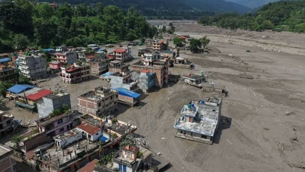
The water followed the Bhotekoshi through Rasuwagadhi and Timure, reached Syabrubesi, and then joined the Trishuli. Communities further downstream, including Mailung, Betrawati, Trishuli Bazaar, and Devighat, were also affected.
Authorities issued warnings for people living near riverbanks in Rasuwa, Nuwakot, Dhading, Gorkha, and Chitwan to remain alert and move away from vulnerable areas.
One thing to note here is that this was not a gradual monsoon-related rise in water level. The event involved a sudden surge of water, sediment, and boulders. According to ICIMOD, the Trishuli River rose by as much as nine meters at Galchhi within around 30 minutes, and by approximately seven meters at Malekhu over a similar period.
Which Bhotekoshi River is this?
Nepal has more than one river known as Bhotekoshi or Bhote Koshi. The river affected by the 26 August flood is the Bhotekoshi in Rasuwa, which flows from Tibet near Gyirong (Kerung) and Rasuwagadhi. Locally and across the border, it is also known as the Lhende or Lende River. Near Syabrubesi, it joins the Langtang Khola and continues into the Trishuli River system.
Thus, this is not the Bhotekoshi River used for rafting in Sindhupalchok, which runs near the Araniko Highway and Kodari. It is a different river valley.
If you were looking up Langtang, Gosaikunda, the Tamang Heritage Trail, or travel on the Kathmandu to Kerung road, this is the river and area referenced in current news reports.
What Caused the Bhotekoshi Flood?
Authorities are still investigating the exact cause of the flood. However, early assessments have revealed several important findings.
The first key finding is that heavy rainfall within Nepal did not cause the flood. The Department of Hydrology and Meteorology said rainfall in Rasuwa around the event was light, around seven millimeters, which cannot explain a flood of this size.
The second finding is that a US Geological Survey record shows a magnitude 4.4 earthquake in Tibetan territory at 8:37 am, approximately 47 kilometers north of Gosaikunda. Nepal’s foreign minister told Parliament that preliminary information suggested the earthquake may have triggered an avalanche that sent meltwater into the river. ICIMOD also reported unusual seismic signals near Jilong. However, it has not confirmed a direct link between the earthquake and the flood.
The third finding is that based on early satellite imagery and field reports, the leading scientific explanation is that an ice-and-rock avalanche entered the Lhende River, temporarily blocking its flow. Water may then have accumulated behind the debris before breaking through and surging downstream. Early analysis of Planet Labs satellite imagery by NDRRMA placed the suspected flood approximately 20 kilometers northeast of the Rasuwagadhi border crossing. Researchers are also investigating whether a glacial lake may have been involved, although this has not yet been confirmed.
ICIMOD has further warned that debris may still be blocking the river near the Nepal–China border. This means it could create a risk of another downstream surge. People living or traveling near the river should continue to follow official safety advice until authorities confirm that the blockage has cleared.
Number of Deaths and Missing Persons
As of the morning of Thursday (11 a.m local time), 27 August 2026, Nepal Police reported 165 deaths. Bodies have been recovered both near the border and far downstream, including in Chitwan, Dhading, Gorkha, Nuwakot, and other districts. As of the evening of 26 August, many of the victims had not yet been formally identified.
Hundreds of people also remain out of contact. During 26 August, the Nepal Tourism Board initially listed 384 travelers as uncontactable. Later public updates referred to 484 people, while overnight reports indicated officials were working to account for approximately 579 tourists, including many foreign nationals.
These figures should be treated with caution. The lists include both people confirmed missing and travelers who have lost phone signal or have not yet been reached. Nepal Police, the Nepal Tourism Board, travel agencies, guides, and embassies are continuing to verify names and locations.
Groups reported out of contact at different points on 26 August included:
- Travelers and pilgrims heading towards Gosaikunda and the Kailash Mansarovar route.
- Security personnel stationed in Timure and along the border corridor.
- Staff from the Rasuwagadhi customs and immigration offices.
- Approximately 60 people connected to the Langtang Khola Hydropower Project, including workers reportedly inside a tunnel.
Chinese state media also reported deaths and a significant number of people missing on the Tibet side of the border. Those figures remain subject to change as search and rescue efforts continue.
If you are trying to locate a family member or friend, please do not rely solely on unverified social-media lists. Contact the relevant emergency numbers listed below, or contact the travel company responsible for the booking.
- Toll-free: 1234
- Hotline: 1144
- Tourist Police: 9851289445
Give the person’s full name, nationality, passport number if you have it, the travel company, and the last place they were known to be. If they were on a group trip, the agency that sold the trip should already be on the tourism board’s list.
Which Places Were Damaged?

The most severe damage reported so far has occurred along a narrow corridor from the Nepal–China border area in Rasuwa to downstream communities along the Trishuli River.
Areas reported to be affected include:
- Rasuwagadhi and Timure, including the customs and immigration facilities near the border
- Syabrubesi, the main roadhead for treks to Langtang and surrounding areas
- Downstream markets and river towns along the Trishuli River, including Betrawati, Trishuli Bazaar, and Devighat
According to government updates, 19 motorable bridges were damaged, and approximately 40 kilometers of paved road were affected. Hydropower plants and substations across the Bhotekoshi–Trishuli river system also sustained damage.
Several flood-monitoring stations on the upper river were also washed away. This has made it more difficult for authorities to monitor water levels and assess the risk of a possible second surge downstream.
Roads and Travel Restrictions

As a safety precaution, Kathmandu Valley Traffic Police stopped vehicles traveling towards Rasuwa, Nuwakot, Dhading, and Chitwan. The Galchhi–Nuwakot–Rasuwa–Syabrubesi Road and the Mugling–Narayangadh Road were placed under warning or closure at different times. Travel conditions may change quickly as authorities inspect roads, clear debris, and assess further risk. Weather conditions also affected rescue operations, with helicopters forced to turn back on some occasions.
Rescue and Emergency Response
By Thursday morning, officials reported that more than 100 people had been evacuated by Nepal Army and private helicopters. Search and rescue teams continue to work in affected areas using helicopters, drones, sniffer dogs, and ground teams. The Cabinet has declared affected local levels in Rasuwa, Nuwakot, and Dhading as disaster crisis areas for three months.
The number of personnel and resources deployed to the flood-affected areas for rescue and relief operations as of 10 a.m. local time, 27 August, include Nepal Army (2000+), APF Nepal (1500+), Nepal Police (3,000+), Helicopters in the field (12), standby helicopters (20), medical team (100+), and many locals, doctors, and volunteers. Furthermore, many relief materials have reached the affected area.
What This Means for Langtang, Gosaikunda, and Tamang Heritage Trek
Syabrubesi is the main starting point for the Langtang Valley Trek, the Tamang Heritage Trail, and many Langtang–Gosaikunda itineraries. The usual Kathmandu–Syabrubesi road, along with the riverside settlements it serves, falls within the affected disaster area.
Current Travel Advice:
- Do not begin a Langtang, Gosaikunda, or Tamang Heritage trek.
- Do not attempt to travel to Syabrubesi by bus, jeep, or private vehicle until the district administration and your trekking operator confirm that the route is open and safe.
- Do not assume that high villages such as Lama Hotel, Langtang village, or Kyanjin Gompa are “fine because they are uphill.” The problem today is access, rescue, and the risk of another flood on the same river.
- Gosaikunda sits high above the Bhotekoshi, but the pilgrimage and trek routes still depend on the same roads and valley towns. A bus of pilgrims traveling toward Gosaikunda was reported out of contact on 26 August. The Himalayan Rescue Association sent a medical team to its seasonal camp at the lake. Until that area is cleared, treat Gosaikunda travel as stopped.
If you have an upcoming trek in the Langtang region, contact your trekking operator and wait for verified advice. Please do not attempt to change your route independently or travel on local buses without confirmation that conditions are safe.
For information about the normal routes and itineraries, please see our Langtang region trek packages, the Langtang Valley trek, the Langtang Gosaikunda trek, the Tamang Heritage trek, and the Kathmandu to Langtang Valley road guide. Those pages describe the normal itinerary. These pages describe normal trekking conditions and should not be considered confirmation that travel is currently possible.
What About Kailash Mansarovar?
Many of the foreign travelers reported out of contact were traveling on, or preparing to join, the overland Kailash Mansarovar route through Rasuwagadhi and Gyirong. Some groups were reportedly at or near the immigration area when the flood occurred.
The Rasuwagadhi–Gyirong crossing should be considered closed to normal travel until border facilities, roads, and the river corridor have been inspected and formally declared safe.
If you are due to depart for Kailash Mansarovar in the coming days, treat your trip as postponed unless your travel company and the relevant authorities confirm otherwise.
Is This the Same as the 2025 Flood?
No. This is a separate disaster affecting the same river corridor.
On 8 July 2025, a sudden flood also came down the Lhende River into the Bhotekoshi. Nepal’s Department of Hydrology and Meteorology later linked that event to a glacial lake on the Purepu Glacier in Tibet, approximately 35 kilometers upstream of the border.
That flood killed at least 9 people, left others missing, and damaged the Nepal–China Friendship Bridge, the dry port, and the Syabrubesi–Rasuwagadhi road. A temporary border crossing was later reopened.
The 2026 flood has affected the same stretch of river, but early scientific assessments suggest a different cause: an ice-and-rock avalanche, a temporary debris blockage, and a subsequent flood surge. It should not be presented as a repeat of the 2025 glacial-lake flood.
The Langtang region also carries the memory of the devastating 2015 earthquake and avalanche that buried Langtang Village. That event was different in both location and cause and does not explain the flood of 26 August 2026.
What Travelers Should Do Now
- Stay where you are if you are already in a safe place in Rasuwa, Nuwakot, or along the Trishuli. Do not walk down to the river to look.
- Keep away from riverbanks, bridges, and low ground. A second flood is still possible while debris sits upstream.
- Postpone new travel to Rasuwa and the Langtang region until officials confirm it is safe.
- Use verified sources. The Nepal Tourism Board has asked visitors not to trust unverified social media lists.
- If you have a booking with Action Nepal Treks, contact us. We will help with dates, not with sending people into a closed valley.

